What is it?
The Geographical Search is an advanced search tool which allows you to locate Scran records connected with a particular area.
You can operate the Geographical Search by clicking on an interactive map or by typing in geographical information such as regional names, place names or postcodes.
Where can I find it?
|
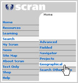
To get to the Geographical Search, choose Search then Geographical from the navigation menu on the left of the screen.
|  |
How do I use it?
You can:
|
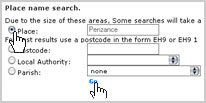
To search by typing in geographical information, scroll to the bottom of the page and enter your search term using one of the text boxes or menus.
You need to choose to search by either Place, Postcode, Local Authority or Parish. Make your selection by clicking the small round button to the left of your choice. You can then continue to either type in the place name or postcode or choose the local authority or parish from the lists given.
Once you are happy with your entry, click Go to perform the search.
|
|  |
|
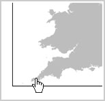
To search using the map, first click on the grey map to indicate roughly the area you want to search. |
 |
|
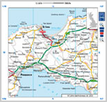
Next, you will see a smaller scale map of the area you selected. |
 |
First, you need to find the location you want on the map:
 |
Use the compass points around the edges to shift position on the map. |
 |
Use the scale tool at the top right corner to zoom in and out. |
Once you can see the area you want to search, use the tools below the map to define your search:
 |
Choose local search or regional search from the menu (choosing regional search will also include the name of the local authority and parish which house the location you selected in the search). |
Use the buttons to mark the place you want to search on the map and launch the search:
 | Click this button then click on the map to mark the position you want to search. |
 | Click this button to remove a marker. |
 | Click this button to launch the search. |
